Sunday, June 27, 2010

Paying Our Dues--A Disappointing Day on the Water. Actually, Days on the Water for Some


By Jim Field

Some days the Fishing God giveth, and other days go the other way. Back in the middle of May, Jon and Tim took Jon's Regulator down the Outer Banks and launched from Oregon Inlet, the plan being to troll--indeed catch--tuna migrating North. The weather was fine and they were right in the hunt with the charters, but no luck was had. Apparently, one day they were North of the tuna, the next day too far South.

On Monday, May 17, Dan and I headed South to Hatteras and asked Jon and Tim if they wanted to accompanying us to Hatteras Village to fish on the Sea Ya Bea. Jon at first declined, being bummed about the two-day skunk and in the mode to put his boat up for sale--totally in jest but understandable. Tim, on the other hand, reminded Jon that they were on holiday, they had set the day aside, so why not go. Jon came around. The next day the four of us headed out to bottomfish in the Stream.

The weather was great and the sea perfect. We fully expected to be (highly) successful. But again, the fish would not cooperate. We caught a half-dozen bottom fish and Dan and Jon had success on the vertical jig. Unexpectedly, Jon brought up a small cod--didn't know they came this far south. We saw some interesting storm clouds, including what looked like a water spout in-the-making, althought one never came to fruition.

Jon's catch on the jig is highlighted today--a Lesser Amberjack. I've included details below and have entered the species in our official catch list.

By the way, we have yet to have a stellar day bottomfishing this year--like we had multiple times in 2008 and 2009. What's going on? We've simply got to turn this around!


Lesser Amberjack


Family Carangidae, JACKS and POMPANOS
Seriola fasciata

Description: olive green or brownish black and silver sides; dark band (variably present) extends upward from eye; juveniles have split or wavy bars on sides; proportionately larger eye and deeper body than greater amberjack.

Similar Fish: other Seriola.

Where found: nearshore and offshore, apparently living deeper than other Seriola (commonly 180 - 410 feet deep).

Size: usually under 10 pounds.

Remarks: smallest of the amberjacks; believed to spawn OFFSHORE; adults eat fish and squid.


Jon's catch using the vertical jigging technique
(He released the fish)


The unexpected cod


The upside-down anvil storm cloud that looked threatening but wasn't

Bluefin Tuna One-Step from Endangered Species Status--Let's Do It!!


By Jim Field

Now we have a petition, in the wake of the oil spill debacle, by an environmental group requesting the U.S. government to declare the bluefin tuna an endangered species and afford it protections that come with this designation. The organization gets an "A" for effort although nothing will happen--even if things go in the bluefin's favor--for many years given complex and cumbersome legal processes. But perhaps it's a start that will attract attention and build momentum for fish conservation. The NYTimes article below, announcing the legal filing, is very informative in that it casts light on unknown spawning practices, the upshot being that no one knows if the oil will kill fish eggs of all kinds--tuna, sailfish, marlin, etc. So we won't actually know for many years the toll the oil might take on fish stocks. One negative leading indicator: the spill occurred in spring--the same time fish spawn in the Gulf. Let's hope the bluefin and other species are not hardwired to lay their eggs in the same place year after year, but are able to move on to water they know/sense to be clean and desirable.

For the record, I favor a total shutdown of bluefin tuna fishing globally for two decades to allow the species to recovery--and indeed survive. Let mankind eat tofu and chicken. And we need to tell Japan to back off or we close our market to their products. Time to play hardball with them, and other short-sighted nations.

Photographs accompanying the article:

Pierside with a newly-landed bluefin tuna


A newly-hatched bluefin tuna


Endangered-Species Status Is Sought for Bluefin Tuna
By ANDREW W. LEHREN and JUSTIN GILLIS

Fearing that the oil spill in the Gulf of Mexico will deal a severe blow to the bluefin tuna, an environmental group is demanding that the government declare the fish an endangered species, setting off extensive new protections under federal law.

Scientists agree that the Deepwater Horizon spill poses at least some risk to the bluefin, one of the most majestic — and valuable — fishes in the sea. Its numbers already severely depleted from record levels, the bluefin is also the subject of a global controversy regarding overfishing.

The bluefin is not the only fish that spawns in the gulf, and while it is often a focus of attention, researchers are worried about the impact of the Deepwater Horizon oil spill on many other species.

In fact, scientists say, it is virtually certain that billions of fish eggs and larvae have died in the spill, which came at the worst possible time of the year. Spawning season for many fish in the gulf begins in April and runs into the summer. The drilling rig exploded on April 20, and the spill has since covered thousands of square miles with patches of oil.

Both the Bush and Obama administrations tried to win greater international protection for the bluefin, but their efforts were derailed by opposition from countries like Japan, where a single large bluefin can sell in the sashimi market for hundreds of thousands of dollars. (The tuna fish sold in cans comes from more abundant types of tuna, not from bluefin.)

The bluefin uses the Gulf of Mexico as a prime spawning ground, and the gulf is such a critical habitat for the animal that fishing for it there was banned in the 1980s. But after spawning in the spring and summer, many tuna spend the rest of the year roaming the Atlantic, where they are hunted by a global fishing fleet.

The environmental advocacy group, the Center for Biological Diversity, in Tucson, filed the request under the Endangered Species Act in late May. If the petition is granted, a process that could take years, the endangered listing would require that federal agencies conduct exhaustive analysis before taking any action, like granting drilling permits, that would pose additional risk to the fish.

Beyond tuna, other animals at apparent risk of harm include the whale shark, the largest fish in the ocean, and a group known as billfish, the foundation of a large recreational fishery in the Gulf of Mexico and the western Atlantic. The billfish that could be affected include the fastest fish in the ocean, the sailfish, as well as blue marlin and swordfish.

“This is a much bigger problem than people are making out,” said Barbara Block, a Stanford researcher who is among the world’s leading experts on the bluefin tuna. “The concern for wildlife is not just along the coast; it is also at sea. We’re putting oil right into the bluewater environment.”

Some of the science documenting the risks that oil drilling poses to spawning fish was paid for by none other than the Minerals Management Service, the federal agency responsible for leasing offshore tracts for oil development.

Yet the results appear to have had little impact on the way the agency carried out its business. For instance, it never adopted seasonal limitations on drilling in the gulf that might have reduced the risk of oil spills during spawning season. It also dismissed the dangers that drilling posed to deep-water fish as “negligible.”

President Obama has acknowledged the agency’s failings. Its director, S. Elizabeth Birnbaum, resigned, and a reorganization of the agency’s functions is under way (last week, it was renamed the Bureau of Ocean Energy Management, Regulation and Enforcement).

The agency responded to inquiries by saying that in light of the Deepwater Horizon spill, its policies — including those for fisheries — were under review.

Given that a single female fish can produce tens of millions of eggs, scientists say that many billions of them would have been in the water on April 20. The vast majority of those would never survive to adulthood even in normal times; now bathed in oil, fewer will make it.

“It’s obvious that any egg or larvae encountering oil will die,” said Molly Lutcavage, director of a research center on large fish and turtles at the University of Massachusetts at Amherst.

Less clear is whether fish would have continued to lay eggs near the spill after it began. Most fish can smell, and researchers hope that at least some species would have avoided spawning in oil. However, fish that can be readily spotted from the air, like whale sharks, have been seen in recent weeks in the vicinity of the spill.

“The question is, does everything shut down if there’s oil there, or do they just go ahead and spawn anyway?” said Eric Hoffmayer, a researcher at the University of Southern Mississippi.

Many important fish in the region, like yellowfin tuna, are able to spawn across broad areas of the gulf, and that means significant numbers of such fish should have hatched this year far from the oil spill.

But other species, including bluefin tuna, apparently have a strong instinct to spawn in a specific part of the ocean. Scientists fear that instinct might overcome the presence of oil in the water, causing the fish to spawn in areas where their offspring would be likely to die. One of the spawning areas in the gulf favored by bluefin is in the vicinity of the spill, Dr. Block said.

The risks the spill poses to fish of all kinds have provoked deep alarm among commercial and sport fishing groups. At least a half-dozen major billfishing tournaments scheduled for June and July have been canceled, and tourists who would normally take deep-sea fishing trips this time of year are avoiding the gulf. The American Sportfishing Association estimated that business owners were losing millions of dollars in a recreational fishing industry worth more than $3.5 billion a year in the gulf.

“It’s having a horrific impact on the marine and fishing industry,” said Dan Jacobs, tournament director for an offshore fishing championship. “The big question is, how long is it going to last?”

Given that it takes some big fish years to reach spawning age, the death of larvae and juvenile fish could have consequences that might not show up for a long time.

“The oil spill could be the last straw with these very vulnerable species,” said Ellen Peel, president of the Billfish Foundation, a nonprofit group that supports recreational offshore fishing.

Friday, June 25, 2010

Will the Oil Slick Come to Hatteras? Supercomputer Model Suggests Odds "Very Likely"


By Jim Field

Well, the million dollar question we're all wondering about is whether the oil slick will travel around the tip of Florida and head North up the Atlantic coastline. How devastating would that be? Answer: very devastating. Earlier this month, on June 4, the WSJournal published an article about the results from supercomputer studies performed by Los Alamos government scientists suggests that the odds of this nightmare happening are "very likely." Wow. More specifically, they are saying there's a "high degree of certainty" that oil will enter the Atlantic within the next six months. What really caught my eye is their expectation that if the oil does indeed enter the "powerful" Gulf Stream, it will move North at a rate of 100 miles a day. [Note: if you want to see a very cool video of the predictive computer model in motion, go to the bottom of this post and click on the word "here".]

The map accompanying the article below


Model Suggests Slick Could Zoom Up East Coast
By ROBERT LEE HOTZ
June 4, 2010

New supercomputer studies suggest it is "very likely" ocean currents will carry oil from the Deepwater Horizon spill in the Gulf of Mexico around the tip of Florida and thousands of miles up the U.S. East Coast this summer, researchers announced Thursday.

"It is truly a simulation, not a prediction," said Terry Wallace, principal associate director for science, technology and engineering at the Los Alamos National Laboratory in New Mexico, which collaborated on the project. "But it shows that when you inject something into the Gulf, it is likely to have much larger consequences."

So far the oil has been confined by strong eddies, but that is almost certainly a temporary respite, say oceanographers.

Researchers from the National Center for Atmospheric Research in Boulder, Colo., and the Los Alamos laboratory used a $100 million computer model of the world's ocean-circulation patterns to assess how currents could sweep the oil out of the Gulf.

The simulations show a strong Loop Current almost inevitably will pull the oil into the powerful Gulf Stream. It would then travel up the Atlantic coast at a speed of about 100 miles a day.
"From these simulations we can say with a high degree of certainty that it is very likely sometime in the next six months that oil from this spill will get into the Atlantic," said oceanographer Synte Peacock of the NCAR, who is running the project. "We can say that when it happens, it will be fast, much faster than anything we have seen so far," she said.

Authorities were already tracking an oil slick a bit more than five miles off the coast of Pensacola, Fla., Thursday. Some branches of the spill could start hitting beaches in the western Florida Panhandle on Friday and Saturday, according to the latest projections by the National Oceanic and Atmospheric Administration.

The Coast Guard said on its website that it had received several reports of an oily substance and tar balls along the Florida Keys. Samples have been sent to a laboratory for testing.

To make their longer-term calculations, Dr. Peacock and her colleagues studied six different oil-spill scenarios.

They injected the electronic equivalent of a dye tracer into the currents of a detailed global ocean-circulation model. To analyze its movements, the oceanographers had divided the seas into tens of millions of interacting segments of computer code.

The simulation takes into account factors such as wind speed, current patterns, temperatures and past weather patterns.

Each simulation took 24 hours to complete, running on several of the world's fastest supercomputers at the New Mexico Computer Applications Center and the Oak Ridge National laboratory.

So far, the studies haven't been reviewed by independent scientists or published.

The simulations aren't precise enough to make predictions about when and where oil might make landfall. The researchers said they couldn't predict the actual behavior of the oil spill because the physics governing the interactions between oil and water are too complicated to model accurately. The injection of dispersants to break up the oil spill also complicates the behavior of the oil in ways that no one can predict.

"In terms of the oil spill," Dr. Peacock said, "this model gives you a big-picture response, not the fine details."


If you want to see a live video of the model click here

Thursday, June 24, 2010

Catching Fish, Identifying Species--A Commitment to Do a Better Job. The Banded Rudderfish


By Jim Field
The Crew has not done a very good job of identifying and recording the fish we catch. The "major" fish types we keep, clean, and eat, and we know these fish well. However, we catch a variety of other fish that we don't keep--that aren't known to taste good and/or are small--and we tend to throw them back without stopping to identify exactly what we've brought (temporarily) onboard. Worse still, we've been known to catch and consume many different types of bottom fish in large quantities where we've been too lazy to do the research to find out exactly what they are (subsequent posts will reveal this). Shame on us for being intellectually lazy. Our grade school science teachers would be unimpressed.

Today marks a new era on the Sea Ya Bea of meticulous recording keeping regarding our catch. Promise.

Looking at this blog, the bottom-most text in the right-hand column is a listing of all fish caught on the boat. It is grossly imprecise as it stands (trust me). I will clean it up over the summer--doing the necessary research on the web and in reference books to accurately record our fishing history.

Let's start today with the addition of a new fish on the list--the Banded Rudderfish. For now I will list it under a "jack" header--probably an incorrect family grouping. Over time we'll get more scientific with names, individual species, families, etc.

Here are the basic facts on the Banded Rudderfish: (I admit: the initial Latin words and scientific terms are Greek to me)


BANDED RUDDERFISH
Seriola zonata Family Carangidae
JACKS AND POMPANOS

Description: fish less than 11 inches long have dark band from eye to first dorsal fin and six prominent bars on body; larger fish are bluish, greenish, or brown; soft dorsal base about twice the length of the anal fin; tail-lobe white tipped.
Similar fish: other Seriola.
Where found: nearshore and offshore over hard bottom, generally in shallower water than other amberjacks; young associated with weed lines or floating debris and may follow sharks and other large fish.
Size: usually less than 10 pounds.
Remarks: adults feed on fish and shrimp; spawns


Dan with the catch. Caught while bottom fishing and vertical jigging at 280 Rocks in approximately 200 feet of water. Dan thinks fish doubles as short rifle.

Hard Ball Tournament Rules--Our Friend Peter Wann Takes a Heavy Hit. Routine Lie Detector Tests? Yup, the Ultimate Buzz Kill


[Caption: Boat co-owner Duncan A. Thomasson is dwarfed by his catch, which was 50 pounds heavier than past winners. (Chris Miller/daily News Via Associated Press)]

By Jim Field

This is simply an incredible--in fact, unbelievable story. Let me state right upfront that I think the Citation crew will win their appeal. They have to. Defaulting on a $1 million prize based on an unrelated technicality is scandalous. Full stop. Let's hope that fairness (and sanity) prevails.

Here's a quick background and summary:

- The protagonist, Peter Wann, is a local Alexandria young man who graduated from my kids' school: St. Stephens & St. Agnes School

- Peter is the brother of Ollie's best friend, Maddie Wann

- Peter came down to the Sea Ya Bea last Friday to introduce himself to me. We had just pulled in from our day on the water (Steve and Dylan Ebner, Andrew and I; post on the trip to come), and he dropped by to chat. We talked about the tournament and what he planned to do in Hatteras across the summer. The night before I talked to his dad, Steve, about potentially asking Peter to join the Sea Ya Bea on days when he isn't mating on the Citation. My impression of Peter: nice guy who is seriously learning the trade.


Well, here's what Peter's been dealing with since we saw him. Poor guy. That said, we're backing Peter 100%. The tournament ruling is ridiculous. Hope they see the light.


Fishing license dispute costs Virginia team $1 million prize in Outer Banks Big Rock Blue Marlin contest

By Annie Gowen
Washington Post Staff Writer
Thursday, June 24, 2010; B01

After a two-hour struggle with the gigantic fish off North Carolina's Outer Banks, Alexandria resident Peter Wann pulled with all his strength and the creature emerged from the ocean depths.

He and his four sport fishing teammates could finally see what they had been struggling against -- an 883-pound blue marlin spanning 137 inches, the biggest fish any of them had ever seen.

"My eyes were wide," Wann said of the June 14 catch. "Once it got up, everybody started freaking out, saying, 'Holy smokes!' Everybody was so excited."

But as the exhausted and elated teammates steamed back to shore -- certain that their catch would win the grand prize of nearly $1 million in the annual Big Rock Blue Marlin Tournament -- they began checking to make sure the paperwork was in order. Wann's heart sank when he read the rule book. He thought the entire boat was licensed to compete. Turns out, all individuals had to have a valid state fishing license. Even Wann, the hired first mate.

His mind raced. He had a license at one time, hadn't he? Heart in his throat, he logged onto the state's Web site as soon as the boat was in wireless range.

Then big, bad news: His license had long expired.

"I looked at it, and I was like, [expletive]," recalled Wann, 22, a George Washington University senior who is studying mechanical engineering.

Wann renewed it wirelessly and hoped for the best. That was at 5:51 p.m. The team had reeled in the fish at 3:16 p.m.

Eight days, two lie detector tests, and hours of scrutiny and agonizing deliberation later, tournament officials made their decision. They would not be awarding the prize to Wann and his teammates from the boat Citation.

Wann had gone to North Carolina for a sunny summer of participating in the sport he loves. And his failure to renew a simple $30 fishing license cost his bosses and teammates nearly $1 million.

"I've had better weeks," sighed Michael A. Topp, a Richmond defense contractor, retired Army colonel and co-owner of the boat.

Topp would not discuss the incident in detail because the team is appealing the decision. But he said: "It has nothing to do with the money. It's about our reputation. We did not cheat. We are honorable men."

Competitive sport fishermen from around the country flock to Morehead City, N.C., each June to compete in the annual Big Rock tournament, chasing marlin that have migrated to the warm waters of the coast to feed off abundant tuna and dolphins drawn to smaller fish hiding in the rocky bottoms.

When Topp, Wann and the other euphoric members of the Citation crew -- including the boat's hired captain, Eric Holmes, and its co-owners, Shawn Kooyman of Chester, Va., and Duncan A. Thomasson of Richmond -- arrived back onshore the day of the big catch, the week-long tournament still had several days to go.

Confident that no other competitor would come close, they imagined divvying up the money.

It was clear that they probably would win, said Richard Crowe, an Atlantic Beach, N.C., resident who serves on the tournament board. The fish was 50 pounds heavier than any other first-prize winner in the tournament's 52-year-history. The closest runner-up this year was a 528-pounder.

As the Saturday awards banquet neared, tournament officials began administering lie detector tests to its top money winners. They say they typically give such tests to verify whether the contestants obeyed fishing times, locations and other regulations. The results for Holmes and Wann raised concern, Crowe said. Tournament officials began an inquiry.

Crowe said that the board is "very confident" in its decision to disqualify the Citation's big fish, citing a "substantial violation in tournament rules." The top prize money went instead to the Carnivore for its 528-pound catch; they otherwise would have won $217,000.

"For the integrity of the Tournament, Big Rock has no choice but to enforce the rules and disqualify the fish," the tournament board said in a statement when it announced its decision.

"Rules are the rules, and you can't break 'em a little bit," Crowe said.

Wann calls what happened an "immature mistake." He said he and Holmes should have acknowledged their concern to contest officials straight away. But he also said the owners and the captain -- who were paying him $500 a week before taxes -- never told him that he needed a valid fishing license to be part of the team.

"I feel bad," he said. "I feel like a part of it was my fault. . . . I'm not the one who bought the boat and had a successful business life. I'm in college."

Wednesday, June 23, 2010

Waiter--"What is this Fish?" Truth in Fish Advertising. Today's Subject: Chilean Sea Bass


By Jim Field

Hopping in and out of restaurants on our fishing trips, the Crew oftentimes encounters menus with strange fish listed as entrees, names we've never heard of before. Half in jest, we wonder where these fish have come from--what explains their only recent appearance in restaurants. Are they new discoveries on the planet, placed now before us in a special cream sauce for the betterment of mankind? No chance. The real story, nine out of ten times, is the old "bait and switch," an ancient marketing ploy where one thing is promised but another delivered.

In the fishing realm today, bait and switch takes two forms. First, an existing unattractive name for a species is replaced with something sounding more mainstream or yummy. Second, the purveyor claims the fish to be "x" but in fact it turns out to be "y". An example of the latter is grouper in Florida: a NYTimes investigative article earlier this year uncovered that grouper is substituted about 80% of the time with something else in the Florida restaurants they sampled. The former use of bait and switch is the subject of today's post--where a name-change takes place. Today's subject: Chilean sea bass. Which I've always imagined to look like a striped bass, or large-mouth bass--you know, the bass we fish for locally. But...I would be wrong.

An article in today's NYTimes peripherally mentioned Chilean sea bass in reporting on fishing in the Ross Sea in Antarctica. Turns out the real name for Chilean sea bass--a mainstay in U.S. restaurants for some time now--is "Ross Sea toothfish," the first word also substituted using Antarctic or Patagonia. Seems this fish stock too is under pressure from overfishing, and of course, poaching.

Unfortunately, menu fish often go extinct in culinary and ecological terms, i.e., they show up for a period of time on menus only to disappear when the targeted fish stock is ravaged--we refer to this as the "fish-of-the-month" phenomenon. Woe the fish that's tasty--it's headed for catastrophe. So went the fate of the orange ruffy (whatever fish that really was) and others like it.

Here are some photographs and facts re our beloved Chilean sea bass--impostor that it is.


The toothfish in all its glory--an artistic photographic image


Its home on the globe: the Ross Sea in Antarctica
(Hey, not Chile!)


Standing on the Ross Sea


The real fish--a huge brute


Caught by long-line technique and gaffed aboard (machinery-assisted)


A poacher as caught by New Zealand air patrol


From a New Zealand dispatch accompanying the photograph of vessel:

An RNZAF [Royal New Zealand Air Force] patrol carrying out surveillance against illegal fishing in the Ross Sea yesterday saw the Triton-1 120 nautical miles within the area managed by the Commission for the Conservation of Antarctic Marine Living Resources (CCAMLR).

The RNZAF crew interrogated the vessel and reported the sighting, Mr Barker said.

“The vessel is flagged to Sierra Leone but appears to be operated by a Spanish company."

“Its detection is of very great concern. New Zealand is committed to combating illegal unreported and unregulated fishing in the Southern Ocean."

“These vessels have wreaked havoc on the valuable toothfish stocks in the Southern Ocean and have also caused considerable environmental damage, including to Antarctic seabirds over the years."

“New Zealand will be reporting the sighting to CCAMLR headquarters in Hobart urgently so all the Commission’s 25 members are made aware of the vessel’s activities,” Mr Barker said.

Response action includes the banning of trade in fish from the vessel and refusing access to members’ ports for the vessel.

The surveillance mission was undertaken through Operation Mawsoni, which is led by the Ministry of Foreign Affairs and Trade to support CCAMLR.

Mr Barker paid tribute to the RNZAF crew who detected the vessel on the 10-hour flight.

“Our long range maritime patrol capability is second to none and New Zealanders should be proud of their efforts,” Mr Barker said.

No whaling ships were detected on the patrol. The Japanese fleet is believed to be closer to Africa than New Zealand this summer.


Damn Japanese; posts on them to follow.

Tuesday, June 22, 2010

Gulf Oil Spill Debacle--Impact on Fish and Wildlife--Brief Overview--Bluefin Tuna Again in Peril


By Jim Field

The NYTimes provided an overview (below) of risk to Gulf fish and wildlife. Informative and sad. For Atlantic coast fisherman (i.e., us), the threat to fish larvae is perhaps the largest worry, in that already-depressed bluefin tuna stocks may be dealt a lethal blow in the Western Atlantic, matching the devastation already accomplished in the Eastern Atlantic. When will people wake up to this gigantic and global man-made disaster--specifically, collapsing fish stocks--that is one component of this oil disaster, but 100-times its importance for the world's eco-system?


Impact on Sea Life

- Brown pelicans and other seabirds often dive into the oil because the slick makes the water look calmer. If they are coated in oil, they will be unable to regulate their temperatures, leading to hyperthermia.

- Plankton, tiny immobile organisms at the base of the food chain, can be killed by chemically dispersed oil.

- All four species of sea turtles in the gulf are threatened or endangered. Some have already washed up ashore, and with numbers already low, it would be harder to rebuild the population.

- Dolphins, which often follow boats to play, have been following response crews, getting near the slicks.

- Shrimp and other shellfish are more vulnerable to oil and chemical dispersants because they are stationary, while some adult fin fish populations may be mobile.

- Fish larvae are most at risk. Bluefin tuna, now spawning near the spill, are of particular concern. The Gulf of Mexico is one of only two nurseries in the world for bluefin tuna.

- Sperm whales, which spend most of their time diving for prey, may come up in the slick as they reach the surface to breathe.

1899 Hatteras Hurricane San Ciriaco--Talk About Hard Times! Makes All Others Look Mild. "Cattle, Sheep, Hogs and Chickens Were Drowned..."


By Jim Field

Returning to Alexandria from our Hatteras fishing trip on Saturday, we stopped by to climb the Cape Hatteras lighthouse. In the gift shop I purchased a National Park Service guidebook to the historic U.S. Weather Bureau Station in Hatteras village, which was beautifully restored a decade ago and now serves as the town's visitor information center. The building is located right downtown, with the Red and White grocery on its left and Captain DM's family home on its right.

The building was erected in 1902 to replace an original structure--a small one-story framed structure. The Federal Government purchased the land for $110.35 and the cost to erect the new station was $5,194.

In 1870, President Ulysses S. Grant established a national weather service, to be headquartered in Washington DC. The plan was to establish weather observation sites across the country that would send weather data to HQ by telegraph three times each day, which HQ staff would use to compile a national weather map and local forecasts. The first coastal observation station in North Carolina was placed in Wilmington in 1871. Hatteras Village was assigned the next NC station in 1874. The data collected consisted of the following:

- Temperature and its 24 hour change
- Relative humidity
- Wind velocity
- Pressure of the wind (pounds per square foot)
- Barometric pressure
- Amount of clouds
- State of the weather

The weather observers lived in the station with his family--a situation akin to that of lighthouse keepers. The Hatteras observer S.L. Dosher (more from him later) wrote of his existence:


"The lonely life one is forced to lead...here and the...continuous round of duty one must perform in keeping up the work alone, where there are none of the diverting pleasures of civilization to break the dull, soporific monotony of the situation, prove after a time to be a strain that depresses even the most optimistic nature, and a physical and an intellectual menace that even the most robust constitution and the strongest mentality can not long withstand."


In reading through the guidebook this morning in bed (Father's Day), I came across a letter that Weather Observer Dosher had written to headquarters about a hurricane that just passed through Hatteras Village a few days earlier. No more than a few paragraphs in, the reader quickly recognizes that this eye-witness account is a remarkable document--no other way to describe it--and I decided that I simply had to post an entry about it. What Dosher describes to his boss is really hard to imagine--the utter devastation that occurred to Hatteras Village and its inhabitants, and his personal travails in dealing with it as both a government official and local himself.

Before re-creating Dosher's letter, however, I decided to do some background research to see if I could find some details about the hurricane in question. Turns out, using the simple keyword "Hurricane 1899," it popped right up on Wikipedia. The hurricane was named "San Ciriaco," and it was a real killer that still holds some records today. From Wikipedia:


1899 Hurricane San Ciriaco, also known as the 1899 Puerto Rico Hurricane, was the longest-lived Atlantic hurricane and the eleventh deadliest tropical cyclone in the [Carribean] basin. It was an intense and long-lived Atlantic Cape Verde-type hurricane which crossed Puerto Rico over the two day period August 8 to August 9, 1899. Many deaths occurred as a result, due to flooding. The cyclone kept tropical storm strength or higher for 28 days, which makes it the longest duration Atlantic hurricane on record and the second-longest anywhere in the world (behind Hurricane John in 1994).

After it passed Puerto Rico, it brushed northern Dominican Republic as a Category 3 hurricane, but passed north enough to not cause major damage. It passed through the Bahamas, retaining its strength as it moved slowly northward. After drifting northeastward, the hurricane turned northwestward, hitting the Outer Banks on August 17. It drifted northeastward over the state, re-emerging into the Atlantic on the 19th.

Estimates of storm-related fatalities range from 3,100 to 3,400, with millions of dollars in crop damage in Puerto Rico. North Carolina had considerable tobacco and corn damage from the longevity of the strong winds and rain.

Also, with an Accumulated cyclone energy of 73.57, it has the highest ACE of any Atlantic hurricane in history. In 2004, Hurricane Ivan became the second Atlantic hurricane to surpass an ACE value of 70, but did not surpass the San Ciriaco hurricane.


Interestingly, Wikipedia also provided a graphic representation of the hurricane's track, which is shown below. Sadly for those in Hatteras, the storm seemed to go out of its way, pausing and making a special westerly detour to ensure it flattened the island and village.


Here, now, is the full letter sent by Weather Observer Dosher to his Chief in Washington, DC, two days after the storm departed.

Note: although a bit long, it's definitely worth a read; it starts out slow and then becomes riveting and unimaginable. From our vantage point of 2010, it's hard to put oneself into the scenario described. But try to imagine what fell on these people, and what it would feel like--the sights and sounds--if James Cameron made it into a 3D IMAX movie! People would be traumatized.


Hatteras Devastated by Hurricane

U.S. Department of Agriculture
Weather Bureau
Office of the Observer

Subject: Hurricane
Station: Hatteras, North Carolina
Date: August 21, 1899

Chief of the Weather Bureau,
Washington, DC

Sir:

I have the honor to make the following report of the severe hurricane which swept over this section on the 16th, 17th, and 18th instantly.

The wind began blowing a gale from the east on the morning of the 16th, varying in velocity from 35 to 50 miles an hour...During the early morning of the 17th the wind increased to a hurricane and at about 4 a.m. it was blowing at a rate of 70 miles, at 10 a.m. it had increased to 84 miles and at 1 p.m. is was blowing at a velocity of 93 miles with occasional extreme velocities of 120 miles to 140 per hour. The record of wind from about 1 p.m. was lost, but it is estimated that the wind blew even with greater force from about 3 p.m. to 7 p.m. and it is believed that between these hours the wind reached a regular velocity of at least 100 miles per hour...

At about 7:30 p.m. on the 17th there was a very decided lull in the force of the wind and at 8.m. it had fallen out until only a gentle breeze was blowing. This lull did not last more than a half hour, however, before the wind veered to the east and then switched south-east and began blowing at a velocity estimated from 60 to 70 miles per hour which continued until well into the morning of the 18th. During the morning of the 18th the wind veered to the south and continued to blow a gale, with heavy rain squalls, all day, decreasing somewhat in the late evening and going into southwest. This day may be said to be the end of the hurricane, although the weather continued squally on the 19th, but without any winds of very high velocity.

This hurricane was, without question, the most severe storm that has ever passed over this section within the memory of any person now living, and there are people here who can remember back for a period of over 75 years. I have made careful inquiry among the old inhabitants here, and they all agree, with one accord, that no storm like this has ever visited the island...

The scene here on the 17th was wild and terrifying in the extreme. By 8 a.m. on that date the entire island was covered with water blown in from the sound, and by 1 a.m. all the land was covered to a depth of from 3 to ten feet. The tide swept over the island at a fearful rate carrying everything movable before it. There were not more than four houses on the island in which the tide did not rise to a depth from one t four feet, and at least half of the people had to abandon their homes and property to the mercy of the wind and tide and seek the safety of their own lives with those who were fortunate enough to live on higher land.

Language is inadequate to express the conditions which prevailed all day on the 17th. The howling wind, the rushing and roaring tide and the awful sea which swept over the beach and thundered like a thousand pieces of artillery made a picture which was at once appalling and terrible and the like of which Dante's Inferno could scarcely equal.

The frightened people were grouped sometimes 40 or 50 in one house, and at times one house would have to be abandoned and they would all have to wade almost beyond their depth in order to reach another. All day this gale, tide, and sea continued with a fury and persistent energy that knew no abatement, and the strain on the minds of every one was something so frightful and dejecting that it cannot be expressed.

In many houses families were huddled together in the upper portion of the building with the water several feet deep in the lower portion, not knowing what minute the house would either be blown down or swept away by the tide...

Cattle, sheep, hogs and chickens were drowned by the hundreds before the very eyes of the owners, who were powerless to render any assistance on account of the rushing tide. The fright of these poor animals was terrible to see, and their cries of horror when being surrounded by the water were pitiful in the extreme.

The damage done to this place by the hurricane is, at this time difficult to estimate...but is believed that the total loss to Hatteras alone will amount to from $15,0000 to $20,000. The fishing business here is the principal industry from which is derived the revenue upon which the great majority live, and it may be said that this industry has for the present time been swept away entirely out of existence...

A great majority of the houses on the island were badly damaged, and 5 or 6 are so badly wrecked as to be unfit for habitation and that many families are without homes, living wherever they can best find a home. The Southern Methodist church building was completely wrecked...All the bridges and footways over the creeks and small streams were swept away...The roadways are piled from three to ten feet high with wreckage...

The telegraph and telephone lines are both down...It is reported that several vessels are stranded north of [Big Kinnakeet Life Saving Station]...

A large steamship foundered about a mile off Hatteras beach..and is thought all onboard were drowned...

The Diamond Shoals Light Ship which was stationed off Hatteras, broke loose from her mooring on the morning of the 17th and was carried southward by the gale...This vessel will probably prove a total loss...

(Photograph of beached Light Ship 69)


The damage to the instruments and property of the Bureau here was considerable...The office building was flooded with water to the depth of about 18 inches, and the rain beat in at the roof and windows until the entire building was a mass of water...

I live about a mile from the office building and when I went home at 8 a.m. I had to wade in water which was about waist deep. I waited until about 10:30 a.m., thinking the storm would lull, but it did not do so, and at this time I started for the office...I got about one-third of the distance and found the water about breast height, when I had to stop in a neighbor's house and rest, the strain of pushing through the water and storm having nearly exhausted my strength. I rested there until about noon when I started again and after going a short distance further I found the water up to my shoulders...I had to give it up again and take refuge in another neighbor's house where I had to remain until about 8 p.m. when the tide fell so that I could reach the office...

I started to the office against the advise of those who were better acquainted with the condition of the roads than I, and continued on my way until I saw that the attempt was rash and fool-hardy and that I was certain to reach low places where I would be swept off my feet and drowned...There has never been any such tide as the one mentioned here.

...The rainfall...was as heavy as I have ever seen. It fell in a perfect torrent and at times was so thick and in such blinding sheets that it was impossible to see across a roadway 20 feet wide.

...Everything went before the fury of the gale. No lives were lost at Hatteras, although many narrow escapes occurred, several families being washed from their homes in the tide and storm. At Ocracoke and Portsmouth, 16 and 20 miles south of this station the storm is reported about the same as Hatteras, with a corresponding damage to property. Reliable details from these places however, being lacking. A pleasure boat at Ocracoke with a party of men from Washington, DC, was lost and a portion of the party were drowned.

There has been no communication with this place by wire or mail since the storm, and it is not known when there will be. It is therefore requested that so much of this report as may be of interest to the public be given to the Associated Press for publication in the newspaper.

Very respectfully,

S.L. Dosher

Observer, Weather Bureau


And there you have it, all in a day's work for faithful Dosher.

Wednesday, June 16, 2010

Hemingway's Pilar--Early Custom Sportfishing Boat. Series of Posts


By Jim Field

As readers of this blog will know, Ernest Hemingway, a pioneering deep sea sportfisherman, is a particular hero of mine, and I have committed to writing occasional posts on his fishing endeavors, a few of which already reside in the library. Today's post kicks off a planned series on his custom fishing boat, which he christened the Pilar--the name of his leading heroine in For Whom the Bell Tolls, his novel of the Spanish Civil War.

The Pilar now rests permanently on terra firma on the grounds of his home in Cuba, the Finca Vigia, which the Castro government preserves as a museum. Being an impoverished nation, both the home and boat are in a terrible state of decay, reportedly undergoing a $1 million renovation (not really big money).

As an introduction to our subject, below I've copied text on the Pilar from a website dedicated to Key West history (www.explorekeywesthistory.com). On posts to follow, I'll try to elaborate on its design, specs, machinery, and so on.
Should be interesting research. (Note: I am not sure all of the facts offered below are accurate. We'll see which ones stand up over time.)


The (borrowed) text:

Returning to Key West from an African safari in 1934, Ernest Hemingway stopped off in New York to take a few meetings. At one with the editor of Esquire, Arnold Gingrich, Hemingway was given a $3300 advance for some short stories. He promptly took himself out to Coney Island to the Wheeler Shipyard and used the cash as down payment on a customized yacht.

Wheeler was known and rewarded for producing exceptional hand-crafted wooden boats. It had begun producing a pleasure yacht called the Playmate in 1920 and been very successful (the model would be produced until 1939.) Hemingway's modifications to the 38-foot version he ordered included a live fish well and a wooden roller spanning the transom to aid in hauling fish aboard. He also requested extra large fuel tanks (diesel) so he could stay at sea for longer periods of time. The boat had two motors? a 75hp for traveling and a 40hp for trolling. And he requested a flying bridge. The photo on the opening page shows Hemingway atop that flying bridge as the Pilar pulls out of Havana harbor.

The finished yacht cost $7500 and was brought to Key West and christened the Pilar. (Not only the name of the heroine in For Whom the Bell Tolls, Pilar is also the nickname for then-wife Pauline.) Through Key West friend and hardware store owner, Charles Thompson, Hemingway gained permission to dock her at the Navy Yard (the Navy was barely using it at the time.) This put the ship at dock only a few blocks from Hemingway's home on Whitehead Street. The photo at the top of this page is of Hemingway and Carlos Gutierrez on the bridge of the Pilar in Key West, 1934. Photo courtesy of JFK Library.

In 1940, when Ernest and Pauline divorced and he subsequently married Martha Gelhorn (whom he'd met at Sloppy Joe's,) they relocated to Cuba and built Finca Vigia (Lookout Farm)? the home on a hilltop overlooking Havana. Pilar was docked at Cojimar.


Pilar in Havana Harbor with EH, at left, on flying bridge


EH and long-time mate Carlos Gutierrez in wheelhouse; love custom of fishing in starched white cotton shirt and pants


Contemporary photo of Pilar, now protected from ravages of direct weather

Tuesday, June 15, 2010

Hammerhead Encounters Off Hatteras--One Donated Fish on One Given Day


By Jim Field

Fishing off Hatteras, we see sharks regularly, lots of sharks. And big ones at that. You scan the water's surface and pick up a dark dorsal fin--a piece of fixed triangular surface area--against a moving background. The size of the dorsal fin--its vertical height--gives you one indication of the predator's size. A second indicator is the distance between the dorsal fin and its tail fin that swings back and forth methodically to propel the animal forward. The Crew never tires of observing sharks; from safety we get to see them in their element, grateful we're not in such a situation as to have to co-habitat the water with them.

Perhaps the most beautiful day of shark "bonding" I experienced occurred this past winter. We were fishing out of Oregon Inlet for tuna and the day and sea state were absolutely perfect. The ocean was literally teeming with sea life--we saw hundreds of porpoise, dozens of whales, boiling balls of baitfish--and we got skunked amidst this plenty for tuna, our target. However, while trolling along the temperature break, which ran hard that day, the water moving rapidly, in small rippling currents, we came across large sharks (species unknown) dead on the temperature break, swimming effortlessly to hold themselves stationary against the current. Here they waited for the fish to come to them. We counted them in passing each one by, spaced perhaps 50 yards apart like highway markers: one, two, three, four, and off into the distance.

Another memorable shark encounter we had was while bottom fishing in February 2009 at the 280 Rocks. We were having great success bringing large fish up from the deep by vertical jigging. One of us (I believe Dan) hooked up a fish that eventually surfaced about 50 feet off our starboard beam. The fisherman began reeling in the fish across the water's surface when all of a sudden we saw this enormous shadow close in from about ten feet under water. It came to the surface and turned 90 degrees toward the boat, chasing down the moving fish. It was a large hammerhead, which proceeded to surgically bisect the catch. Like all hammerheads in these waters, its top two-thirds was colored a light chocolate brown, its underside a rich creaming white. Nothing short of stunning. We watched in awe as it closed, struck, and departed. That was that. Hello and goodbye. Thanks for the snack, boys.


Stunning creature, a wonder of evolutionary adaption


Remains of the day as exhibited by Dan; black finger of death points to location of thief in the water

The Crew at pier side, with noteworthy production of five blackfin tuna (closest to boots) caught by vertical jigging. Left to right: Dan, Fran Senior, Captain Jim, and Joe Irons

Hatteras Dreaming--Looking Forward to August


By Jim Field

This year the Fields and Dan/Dina Okoniewski are renting houses in Hatteras Village during the first week of August. (The Fields will be there for three weeks: last week in July through second week of August; so we have one week together.) Yesterday I was down in the Village to perform boat maintenance and prepare for this weekend's fishing trip. I stopped by to check out both properties, and have posted pictures below. The O's place is literally a 3-4 minute walk from Teach's Marina. The house looks well maintained on a quiet off-street. (Underscore quiet.) The Field's house is three streets further down the beach from Teach's, and is about a 3-4 minute walk from the Os. The dunes in front of both homes are big and beautiful. The beaches are awesome and private--no wall-to-wall umbrellas here.

Looking forward to a wonderful time together: swimming, relaxing, food, friendship, and oh yes, doing some boat exploring to other islands, where pirate's hung out (and still do).


Path from O's house leading to the beach


The O's semi-private beach (the water looked great)


Looking North from O's dune; Field's house in second/furtherest cluster of homes at left


The Field's house--can't wait to get there


The path to the beach from Field's abode

The beach in front of the Field's HQ


Looking right from balcony, South towards the Os and Teach's Lair


Looking left from balcony to the north

Tuesday, June 8, 2010

First Time to Hatteras--A Genuine Expedition. Four Years Ago Already


By Jim Field

Just two months and four years ago (April 2006), Dan, Uncle John, and I took the Sea Ya Bea south to Cape Hatteras for the first time. Dan and I had been fishing together for more than a year by then, and saw in each other a love of the sport and interest in trying different things. Uncle John was someone new to me, married to Dan's Aunt Chrissie and a sportfisherman going back to the 1960s-1970s, when the norm (for some) had been to take small, single-engine center consoles far, far offshore--no Loran, no GPS, no life raft, one radio (yet courage and fortitude a must). Being new to deep sea fishing, I knew nothing of Hatteras and its renown as perhaps the best sportfishing waters in the world. To me, Hatteras meant Nags Head, Duck, beaches, lotion, and swimming--that was all. Dan, on the other hand, a long-time fisherman, knew what went on in Hatteras, and, after one of our fishing trips the previous summer, suggested that we should take the Sea Ya Bea down there and give it a try and check things out.

In the moment, we agreed this would be great: "Let's do it! Wouldn't that be incredible? We need to break out of Delaware and give it a go!" Of course, with a few beers under the belt, and the beauty of a day on the water still casting a residual glow, fishermen tend to think grand thoughts, plan grand schemes, and then......forget about them entirely once back to work and life's routines. It all sounds great in theory; it makes one feel free, to exercise the illusory ability to live life boldly on a whim; but then reality sinks in (takes no more than 5 minutes), slamming the door shut on such ridiculous, ludicrous thoughts.

Lights, camera, action!
Sinking a pointed finger into their chests, Reality says to the boys: "Who the hell are you to think you can do this kind of thing? Get back in line, you peasants, you slaves, you low-lifes, maybe someday you'll do this (ah, not really), but it's not going to be anytime soon. Crawl back into your boxes like good adults, and shut up! Now! Before I really lose my temper!"


But, for whatever reasons and circumstances (fate, karma, planets/stars aligning themselves in the universe???), this time around, across the next few months, this one particular hypothetical proposal didn't drift away, but rather got caught up in our minds and conversations (like leader wrapped around a prop), and by refusing to go away, slowing embedded itself as something we were actually going do.

At some point, Dan and I set a date, and Dan recruited Uncle John. Then "the date" became a whole week that we would set aside to make the journey, as we would need a buffer given the unpredictability of good weather. We shook hands, committed ourselves to our mates and idea, and went about our business, waiting for the weeks and months to pass until our "expedition" would begin.

(One thing that escapes me now: where were the wives in all this? Can't believe we were so bold as to ask for a whole week off! What were we thinking?!!!)(Whatever it was: we need some of this mojo back!!!)(Can you believe we attempted this trip thinking we would get a 4-5 day window of good weather? This rarely happen! About as frequently as back-to-back good summiting days on Everest. But it worked out, showing the fishing God loves dummies (occassionally).)

Well, the days and weeks passed by--like in the old movies where the wind blows the pages away--and we gathered at Bethany for the trip South. Only one problem--the weather wasn't cooperating. A front was passing through, and the wind and seas were inhospitable. Thus we'd have to wait it out. We bunked down in Jim/Diane's beach house in Bethany proper, and proceeded to eat and watch movies to pass the time. (The photograph from the house's balcony attests to the gathering storm.) We had the Sea Ya Bea all ready to go, so we had nothing else to do. After dinner, we spread out on the floor to watch movies--we hadn't furnished the family room yet; inevitably, before we'd get through the opening credits, Uncle John was out cold--sawing some big, big, logs.

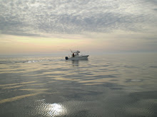
After two days on the dole, the forecast cleared and we decided to go for it. We departed Indian River with first light and turned right (South) out of the breakwater, setting course for a waypoint off of Ocean City inlet. With OC's amusement park easily within sight, we refined our course and drew a line directly to the Point--a magical spot of fishing water SSE of Oregon Inlet, NC. Passing the mouth of the Chesapeake Bay (off Norfolk, Virginia Beach, and the Bridge-Tunnel), we were 50 miles out. Upon reaching the Point, we had caught up with the tailing weather and found ourselves among swells (termed "rollers") with gigantic shoulders--maybe 20 feet high, but benign due to being 20-30 seconds apart. I remember us shutting down from cruising speed, deploying fishing gear, with Uncle John in the cockpit framed by towering waves behind him. Beautiful deep blue waves. I also recall encountering a merchant ship--a container carrier--laboring in the seas and being fascinated by its motion and the surrounding colors. At some point, I went below to take a nap, and was awakened by a loud bang--we had hit something. I went topside at the same time that we got a fish on--line peeling off the reel. I was invited to take the rod and we brought a medium sized mahi-mahi onboard. We apparently had hit a floating pine 2x4, which the mahi was parked under.

With one fish in the box, and the afternoon hours (and daylight) marching on, we picked up gear and headed for Hatteras Inlet. We steamed another 40 miles South and then navigated another 25 miles NNW and then NNE around Diamond Shoals and Hatteras lighthouse. Approaching the inlet, we had been forewarned about its difficulty: perpetually shifting sands, sand and rock reefs, the potential for big waves in the inlet itself if tide and winds were going against each other--in other words, there was a real possibility of going aground. Feeling our way, we observed the ferrys shuttling passengers and vehicles to the next island and fell in behind some other fishing vessels entering the Hatteras marinas. We tied up at Oden's dock--one of four marinas for private boats. Our Dan had arranged things with Dan Oden, the current member of the Oden family with a big hand in running their various Outer Banks businesses.

All told, the day's trip from slip-to-slip had taken us 11 hours. Our cruising speed averaged 25 knots (pretty darn good). We burned about 350 gallons of diesel (from a 400 gallon tank). We transited roughly 230 nautical miles. And we had arrived safely.

That evening we spent our first night (of many to come) as guests in the Breakwater Motel--also owned by the Odens and located right behind the boat slips. We could look outside our room from the balcony and observe the 
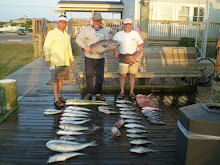
Sea Ya Bea at rest. Next morning we fished all day, trolling, and caught and released 18 small tuna. No keepers but busy all the time--so a great day. The day after we trolled again and saw tons of nature--I recall watching mahis flying through the air in huge archs--but we effectively got skunked, almost hooking up in the final seconds with a keeper tuna. Ironically, on this day the ocean was flat calm--glass-like--and here I learned that while flat sea conditions are good for stomachs, they're terrible for fishing, the best fishing days being characterized by 1-3 foot waves and 5-10 knots of wind. In short, the surface waters have to be interesting. (During this first trip we were clueless about the world-class bottom fishing in Hatteras--had we known this, Dan would have never let us troll.) Dinners, by the way, after fishing were good; on this first trip we discovered Dinki's, which we return to religiously. (There are only 2-4 restaurants open n Hatteras Village in the off-season.)

Inevitably, and all too soon for the three of us, the day came to return home. The morning of our departure was absolutely beautiful. We transited back to Delaware without problems/issues, and tied up on B dock in Indian River marina around 4:00 pm.

What had we found, and what had we learned? Well, we demonstrated that we could take voyages beyond Delaware and Maryland waters and return alive; the world indeed is round. We discovered NC fishing and, in particular, fishing in the Gulf Stream with its abundance of sea life, big game fish, and warm deep-blue crystal-clear water--water that you never see up North. And we were introduced to Hatteras Village, recognizing even on this first encounter that it was a very special place for fishing, beaches, and outdoor living and hunting. I'll give us credit--we knew something spectacular when we saw it and it didn't take long for us to figure this out.

At the time, and in retrospect, all three of us viewed our adventure as a fantastic trip. It was fun--and different--and not something everyone was doing, at least the fishermen we knew. But admittedly, there was a big downside to our journey, and that was that we now wanted to go back: immediately. Having tasted it, we wanted more. But unfortunately, a return wasn't in the cards anytime soon, and maybe never. Alas, better to have experienced it once than never. Bull! We had to go back! But how? And when? And how long would be have to wait?


Uncle John at his fishing station, vigilant like all good fishermen
(His footprints are now bronzed on deck as a memorial)


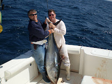
The mahi produced by hitting the board near the Point


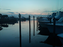
Oden's Dock with Sea Ya Bea moored (at center)


Uncle John near his station taking in beautiful morning; we were to depart that morning


Minutes from casting off for Delaware. Miss Hatteras clients look on. Uncle John serenades them by whistling Beethoven's 5th


Back at Indian River DE safely. Jim and Uncle John have a "cold one"


Dan and Uncle John, a great pairing to fish with


Dan and Jim: One adventure accomplished--with more to follow